Vrmac Ridge
The long forested ridge between the Kotor and Tivat bays: its two-bay viewpoints, the marked hike along the crest, the Austro-Hungarian Fort Vrmac, easy cycling on the old tracks, and how it differs from the city-walls climb.

- ✓Vrmac is the green, forested ridge that separates the inner Bay of Kotor from the bay of Tivat — a long spine you can walk, drive partway up, or cycle.
- ✓The reward is a rare double view: the Boka and the Kotor–Perast inner bay on one side, the Tivat bay and the open sea on the other.
- ✓On the crest sits Fort Vrmac, a ruined late-19th-century Austro-Hungarian fortress — atmospheric, unticketed and free to explore with care.
- ✓It is shadier, gentler and far quieter than the city-walls climb to St John Fortress, with no ticket and no crowds.
- ✓Old military tracks and gravel roads make Vrmac good cycling and gentle hiking country, with marked trails on the regional walking network.
- ✓There is little shade in places and no facilities on the ridge, so carry water, sun cover and sturdy shoes, and check the weather before you go.
What Vrmac is, and why it rewards the effort
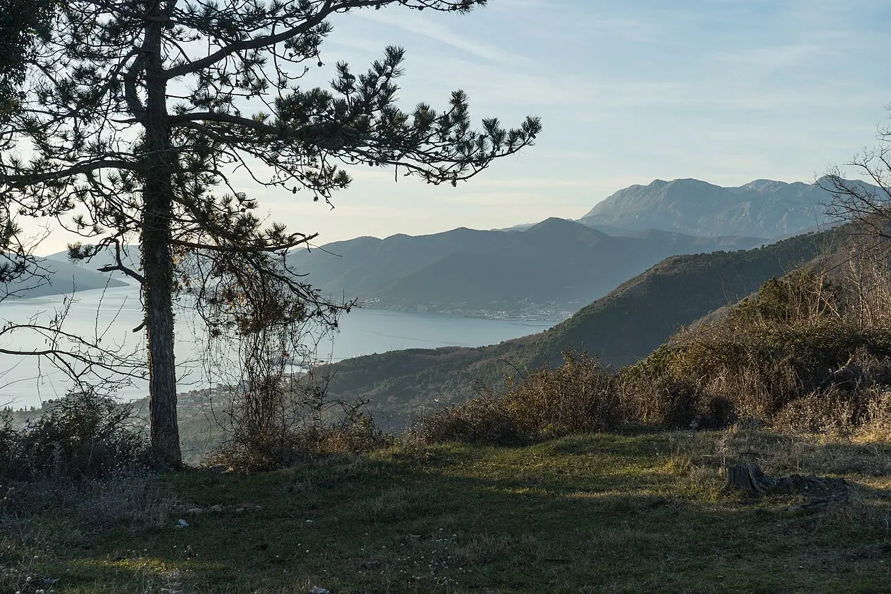
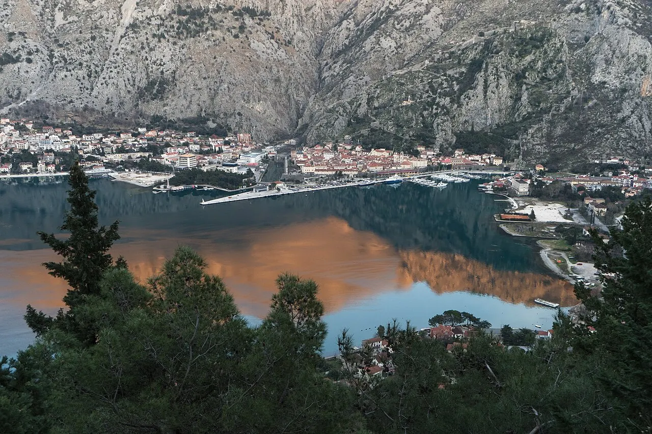
Vrmac is the long, wooded ridge that rises between Kotor and Tivat, dividing the inner Bay of Kotor from the broader Tivat bay to the south. Where the bare limestone of Lovćen towers behind Kotor, Vrmac is greener and gentler — a spine of pine, oak and scrub with old stone hamlets on its lower slopes and a crest you can follow for kilometres. It is the bay's quiet alternative to the headline climbs: a place to walk, cycle or simply drive partway up for a view, away from the crowds that fill the Old Town.
The headline reward is the panorama. Because the ridge sits between two bays, the top gives you both at once: turn one way and the inner Bay of Kotor unfolds toward Perast, the islands and the walled town beneath its fortress; turn the other and the Tivat bay, Porto Montenegro's marina and the open Adriatic spread out toward Luštica. Few viewpoints in Montenegro hand you that much in a single turn of the head, and almost none of them ask for a ticket.
There is history in the green, too. The lower slopes hold old stone hamlets and the upper village of Gornji Stoliv, half-abandoned and threaded with chestnut woods, where a steep path once linked the ridge dwellers to the bay below. Higher up, the Austro-Hungarians left their mark in the brooding shape of Fort Vrmac on the crest. Put together — forest, ruins, a vanishing village and that double view — Vrmac feels less like a single attraction than a whole quiet half-day, the side of Kotor most day-trippers never find time for.
Hiking the ridge
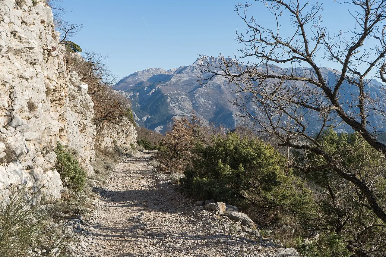
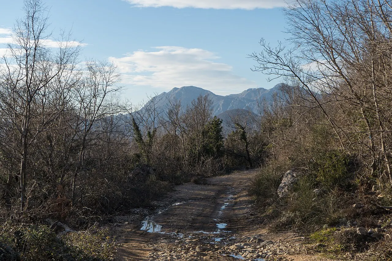
Vrmac is genuinely good walking country, threaded by marked trails that form part of the bay's wider hiking network. Routes climb to the ridge from several directions — from the Kotor side near Muo and Škaljari, and from the Tivat side and the village of Gornji Stoliv — meeting an old crest road and military track that runs the length of the spine. You can tailor the effort: a steady out-and-back to the nearest viewpoint, or a longer traverse along the ridge with the bays alternating beside you.
The classic objective is the crest and Fort Vrmac, with a relatively gentle final stretch once you gain the ridge road compared with the relentless steps of the city walls. Allow a few hours and pace yourself for the heat: much of the lower climb is sheltered by trees, but exposed sections bake in summer. Trails are signed in the regional system but waymarking can be patchy in places, so a downloaded map or GPS track is worth having, and it is wise not to wander off the marked paths — old military ground means the occasional unstable structure. Verify current trail conditions and the best access point locally before you set out, as paths and signage change.
One particularly rewarding line climbs from Gornji Stoliv: from the bay shore at Stoliv a steep old stone path threads up through chestnut woods to the half-abandoned upper village, then on to the ridge, so you can stitch together a boat or bus to the waterfront, the climb, the crest with its fort, and a descent the other side. It is more effort than a simple out-and-back, but it knits the bay, the forest and the fortress into one walk. Spring and autumn are the kindest seasons here — the woods are cool and green, the air clear for the views, and the summer haze and heat have lifted.
- Marked trails climb from the Kotor side (near Muo/Škaljari) and the Tivat side (via Gornji Stoliv) to a crest road.
- Tailor it: a short out-and-back to a viewpoint, or a longer traverse along the ridge.
- Gentler and shadier than the city-walls steps once you gain the ridge — allow a few hours.
- Carry a map/GPS, stick to marked paths, and verify current trail conditions locally.
 The Ladder of Kotor
Another quieter, switchback walk above the bay if you want an alternative to the stairs.
 The Fortress Hike
Compare the famous walls climb with Vrmac's gentler ridge walk.
Map pins
Map data © OpenStreetMap contributors · Tiles © OpenFreeMap
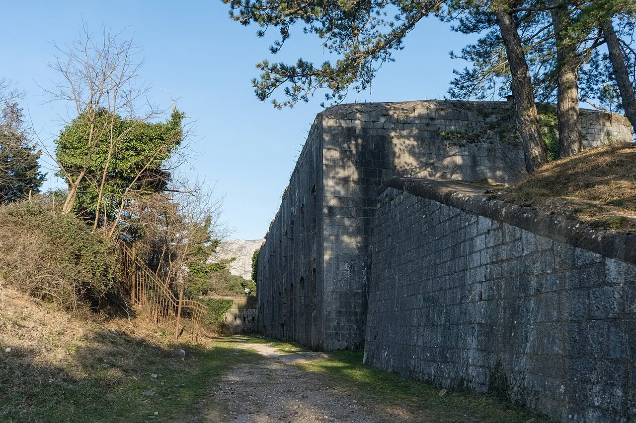
Fort Vrmac on the crest
The ruin that crowns the ridge is Fort Vrmac, a late-19th-century Austro-Hungarian fortress built to command both bays when this coast guarded the edge of the empire. Squat, grey and brooding, it was constructed in stone and concrete and later strengthened, and it saw action in the First World War. Today it stands abandoned and weather-worn on the high ground — a different kind of fortress experience from polished St John above the Old Town: raw, empty and quietly dramatic, with the wind and the view for company.
It is free to reach and unticketed, but it is also genuinely a ruin, so explore with care. Floors and openings are not maintained, surfaces can be loose underfoot, and there are drops; keep children close, wear proper shoes and do not climb on unstable structures. The payoff is the setting — the same commanding two-bay panorama the fort was built to exploit, now yours to enjoy without the soldiers, the crowds or the entry fee. Bring a torch if you want to peer into the darker chambers, and treat the place gently.
- A late-19th-century Austro-Hungarian fortress, abandoned and atmospheric, on the high crest of the ridge.
- Free and unticketed — but a genuine unmaintained ruin: loose surfaces, open drops, no railings.
- Wear sturdy shoes, keep children close, bring a torch and don't climb on unstable structures.
- Built to command both bays — so it shares the ridge's best panorama.

Cycling and driving Vrmac
Vrmac is not just for walkers. The old military road and the network of gravel tracks that run along and up the ridge make it some of the better mountain-bike terrain near Kotor — long, scenic climbs on dirt, a rolling crest with views into both bays, and descents back down to the water on either side. Riders with their own gear, or a guided e-bike or MTB tour, can link Vrmac into longer loops around the bay; it is a far quieter, more rewarding ride than the busy coastal road below.
By car or scooter you cannot drive the whole crest, but you can gain a good deal of height on the access roads from the villages on either side and reach a viewpoint with much less effort than the hikers put in — handy if walking is not your day's plan but you still want the panorama. Roads on the ridge are narrow, sometimes rough and unsurfaced, and not always signed, so go slowly, carry enough fuel and water, and verify which approach is currently driveable before you commit. As ever on Vrmac, there are no facilities up top: fill up before you climb.
- Old military roads and gravel tracks make Vrmac good mountain-biking country — bring your own bike or join a guided MTB/e-bike tour.
- By car or scooter you can gain height on the access roads to reach a viewpoint with far less effort than the hike.
- Ridge roads are narrow, sometimes rough and unsigned — drive slowly and verify the driveable approach first.
- No fuel, water or facilities up top — fill up before you climb.
Vrmac vs the city walls: which climb is for you?
It is worth being clear about how Vrmac differs from Kotor's signature climb. The city walls to St John Fortress are the famous, ticketed ascent that begins inside the Old Town: a steep stone staircase of roughly 1,350 steps up to about 260 m, with the postcard view straight down onto the walled town and the inner bay. It is unmissable — but it is also crowded on cruise mornings, exposed to the midday sun, and hard on the knees.
Vrmac is the antidote. It is longer overall but far gentler underfoot, much shadier in its wooded stretches, free and unticketed, and you may have the whole ridge to yourself. The view is broader — two bays instead of one — but more distant from the town itself, so it trades the dramatic looking-straight-down angle of the walls for a wider, calmer panorama. The simple rule: come to the walls for the iconic close-up of Kotor and the badge of having done the climb; come to Vrmac for solitude, forest, the two-bay sweep and a ruined fortress all to yourself. With time for both, do the walls at sunrise and save Vrmac for a quieter, slower day.
- City walls: famous, ticketed, ~1,350 steps to ~260 m; the iconic close-up of the Old Town, but crowded and exposed.
- Vrmac: longer but gentler, shady, free and quiet; a wider two-bay panorama and a ruined fortress to yourself.
- Walls for the postcard and the badge; Vrmac for solitude, forest and the broad sweep.
- With time for both: do the walls at sunrise, Vrmac on a slower day.
Vrmac Ridge at a glance
Use this quick card to plan a Vrmac day. The ridge, the view and Fort Vrmac are free and evergreen; the volatile details — trail conditions, signage, which access roads are currently driveable, and guided-tour availability — change, so verify them locally before you set out.
- What it is: the forested ridge between the Kotor and Tivat bays, walkable, cyclable and partly driveable.
- Cost & hours: free and unticketed, including Fort Vrmac — open any time, no facilities up top.
- The view: a rare double panorama of the inner Bay of Kotor and the Tivat bay/open sea.
- Hiking: marked trails from the Kotor and Tivat sides to a crest road; allow a few hours.
- On the crest: ruined Austro-Hungarian Fort Vrmac — atmospheric but a genuine ruin; explore with care.
- Cycling: old military roads and gravel tracks make good MTB/e-bike terrain.
- Bring: water, sun cover, sturdy shoes, a map/GPS and a torch for the fort; there are no facilities.
- Verify locally: trail conditions, driveable access roads and tour availability.

Things to Do in Kotor
The best things to do in Kotor: the walled Old Town and its squares, St Tryphon Cathedral, the climb to St John Fortress, the cats, the viewpoints and a boat out onto the bay.
Read guide
Best Viewpoints in Kotor
The best viewpoints over the Bay of Kotor, ranked by effort and payoff — St John Fortress, the halfway church, the Ladder of Kotor, the cable car, the Vrmac ridge, the serpentine roadside pullouts and the angle from the water.
Read guideLadder of Kotor Hike
A hiker's guide to the Ladder of Kotor (Kotor Serpentine) — the old switchback caravan trail that climbs the mountainside above the bay: the effort, the viewpoints, timing, heat and safety, and how it compares to the city-wall stairs.
Read guideMore in Things to Do
6
Aquarium Boka
Visit Aquarium Boka, Montenegro's public aquarium in Dobrota just north of Kotor's Old Town — what's inside, family timing, tickets, the species on show, and the flat bay-side walking route to reach it.
Read guideBay of Kotor Scenic Drives
The best drives around the Bay of Kotor: the shoreline loop through Perast and the captains' villages, the white-knuckle Kotor–Lovćen serpentine, the Kamenari–Lepetane ferry shortcut, plus photo stops, summer traffic and driving cautions for each.
Read guide
Beaches Near Kotor
Where to swim near Kotor: the honest truth about the inner-bay town beaches, the quieter bay swims at Dobrota, Prčanj, Stoliv and Muo, the clear-water Luštica coves like Žanjice, and the sandy options down the coast at Budva.
Read guideBest Tours in Kotor
Which Kotor tour to book and why: Old Town walking tours, the fortress climb guided or solo, bay boat trips to Perast and the Blue Cave, food and wine tours, Lovćen and Cetinje mountain day trips, cruise shore excursions, and private boats and yacht charters.
Read guide
Cats of Kotor
Why cats are part of the Kotor experience — the maritime backstory, where to find them in the Old Town, how to photograph and feed them responsibly, and the small charities that care for the bay's free-roaming cats.
Read guideDobrota Promenade
The waterfront walk north of Kotor: how to stroll, swim and café-hop along Dobrota's seaside promenade, past captains' palaces and bathing ladders, with the walled Old Town and the mountains across the bay the whole way.
Read guide